
The Roads of Newington
Introduction
It's reasonably clear from the 1897 layout of the Military Magazine at Newington that it was focused on issuing and receiving ammunition by water, with internal transport from the wharf by a hand-propelled tramway system. The only road known to have been present ran between the wharf area and the three residences. On the earliest map available, from the early years of the Navy occupancy, this road is shown as continuing towards the western boundary of the property, as if in anticipation of a connection to the then unmade Jamieson Street. This map is shown below; north is to the right. The branch to the right goes to the wharf area, terminating in a turning loop adjacent to the guardhouse. The branch at top left goes towards the western boundary where the main road entrance was later established.

According to a newspaper report from 1897 "The wet weather has made the roads to the site very bad, and it is hard work to get the bricks carted to the works." ( see Erection of First Buildings at Newington Powder Magazine).
The most feasible road into the depot at that time was via Sutherland Street (later to become Silverwater Road), Holker Street and Jamieson Street. However Jamieson Street and that portion of Holker Street east of the Newington Asylum (later Newington State Hospital) were unmade roads at the time. The bricks would have been carted by either bullock or horse teams that could cope with unmade roads in drier weather.
There is also a possibility that the old entrance road to Newington House, which ran south through the Newington estate to an entrance on Parramata Road just west of Haslam's Creek, was still available in 1897. This road is shown on the map fragment below (source unknown) dated about 1869. (The creek is shown with the older name of Hacking Creek)

Source Unknown
The Western Entrance - Jamieson Street
Internal correspondence from the Works and Services branch of the Department of Interior in 1937 says that it was not until that year that the modern road access to the depot (Jamieson Street) was constructed by Lidcombe Council with the Commonwealth paying the costs. This came after the Commonwealth had paid for damage caused to roads within the Newington Hospital by vehicles delivering heavy building materials to the depot. The correspondence also says "The route of this road passes partly through the adjacent Hospital owned by the state and partly along an unmade public road under the control of the Lidcombe Council." A sketch map included with these papers shows the line of the proposed work but also shows a “track now in use” entering the Hospital at its main gate, named as Hezlett Drive, and then after some distance proceeding diagonally in a north-easterly direction towards the Magazine. It's clear that until 1937 there was no public road access to the eastern side of the depot.

It seems likely that before the opening of Jamieson street in 1937 the residents of the Magazine used the informal short cut through the Hospital to travel to Auburn or Lidcombe for their domestic necessities. Anecdotal evidence from resident June Madden is that pedestrians were still taking a short cut through the pig farm in the Hospital grounds in the 1950s. In 1937, however, there was no necessity for ammunition to leave or arrive by road but that all changed as World War 2 developed.
The Abattoirs Road
In 1901 a Military Committee of Inquiry reported on the Newington magazine. Its report said that "There is a road from the Magazines to Rookwood (later Lidcombe) Railway Station, 10 miles from Sydney." (1)
It is not clear which route is being referred to here. It is most likely one of those discussed above in relation to the transport of bricks in 1897.
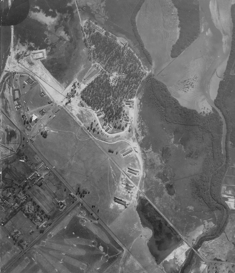
The Abattoirs Road, later to form part of the Burma Road, is depicted on the 1917 Defence Department 1:63,360 ordnance survey map (see below). It runs south from a point which appears to be just short of the magazine's then southern boundary (about where present Holker street runs), crossing Hacking's (Haslam's) Creek via a timber bridge and passing to the south-west of the Homebush Abattoirs where it terminated.
A 1930 aerial photo (CAC_10_1257) confirms that this road stopped short of the Magazine. A finer line on the photo, most likely a fence line, does continue on to the Magazine boundary fence.
The western side of Haslam’s Creek was private land until the NSW government in 1914 resumed 217 allotments of land north of Fariola Street from the Riverside Heights estate for stockyards in connection with the Homebush Abattoirs. (The Cumberland Argus and Fruitgrowers Advocate, 26 June 1915). In the event the land wasn’t used for stockyards but for spelling purposes so this road seems to have been for internal access to the spelling paddocks. It seems likely that the road bridge was constructed about 1915 when levee banks were constructed on the west side of Haslam's Creek to reclaim tidal flats for spelling paddocks.
In the map below this road is the one overlaid by the word "Insane".

The Burma Road
Much of the Abattoirs Road was eventually taken over by the armament depot through land acquisition as it expanded southwards during World War 2, eventually comprising the entire length of the road west of Haslam's Creek. Clearing of building sites for shell (buildings 46-49) and cordite (buildings 42-45) stores started around 1939. The connected road can be seen in a January 1942 aerial photo. It appears as a prolongation of the road heading south from the "5 Ways" at Newington and holding a direct line to the crossing point of Haslam's Creek. The road was used during the war to access the Homebush Brickworks which had been taken over by the Navy as ammunition stores. After crossing Haslam's Creek the route used internal Abattoirs roads to reach the Brickworks. The portion within the depot was colloquially known thereafter as the "Burma Road", and as early as 1943 a Department of Works drawing (NSW DEF 36419) named it as "Burmah Road".
In the photo above the "Burma Road", which connected the site to the Homebush Brickworks, is shown crossing Haslam's Creek at bottom right. At bottom left is the Carnarvon Golf Course, soon to be the site of the US Navy magazine, and at centre left is the Newington Hospital.
The Auburn Entrance
During World War 2 the the depot expanded southwards almost to Parramatta Road, the main east-west highway in the vicinity. A third entrance was therefore opened about 1944 on Adderley Street near Alban Street, Lidcombe. This served not only the ammunition storehouses but also the workers of the laboratories that were constructed in the southern part of the depot. This entrance continued in use until 1972 when land was surrendered to the NSW State Government for the construction of the current M4 motorway.
Other Named Roads
Some other internal roads and localities within the depot acquired names by common usage. These included "The Little Bull Ring", for the road serving the first set of magazines constructed for the US Navy (buildings 54-61) due to the shape of the road layout, "The Bull Ring" for the road serving the second set of US Navy magzines (buildings 62-74), due to the circular shape of the road layout. Finally, "The Concrete Road", named from the material of either the road surface or the buildings along its length, extended from the Burma road southwards to the Auburn entrance. The Little Bull Ring was named "The Banana" in some later heritage studies. The "5 Ways" was the major road and rail junction within the depot.
The development of the road network during World War 2 can be visualised through 3 aerial photos of the depot made in 1942, 1943 and 1946. These are available on The Experience of War 1939 - 1945.
Notes:
1. For more information about this Committee's report see: The Newington Military Magazine in 1901
Read more about the Military Magazine.
Material on this page may be copied for personal use. If you intend to republish any substantial part of the page in any manner, please acknowledge the source and provide the URL of the page.